
Summary: 1 day Hannel's Spur hike
Date: 11 December 2022
Region: Kosciuszko National Park
Introduction
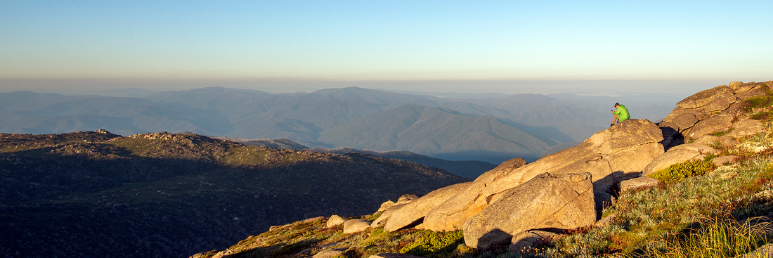
Hannel's Spur is the greatest vertical ascent in Australia, following the same route that Strzelecki took as the first European to climb Kosciuszko in 1840.
Day 1
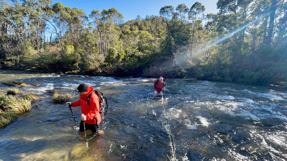
We left Jindabyne early and drove to Thredbo where we left two cars and then drove to Geehi to the start of the Hannel's Spur track. We normally start the hike at a small car park opposite Dr. Forbes Hut. After all of the rain the Swampy Plain River was flowing heavily and after a short attempt we decided to abort the crossing as it was too dangerous. We returned to the car and drove down to the Geehi Campground and started the walk, at around 0800, from there, making the hike slightly longer.
Just prior to reaching Dr. Forbes Hut we had to cross the Geehi River. The Geehi was flowing as well but although a longer crossing than at Swampy Plain the water here was not quite as deep and someone had left a brand new rope across the river making it relatively easy to cross.
We stopped briefly near Dr. Forbes hut to put our boots back on before the climb. We then headed to the start of the track and started the ascent. There were a few trees across the track that we need to climb over and an Eastern Tiger snake that was basking in the sun right on the track. He not going to move so we had to revert to a bit of bush bashing to get around it.
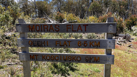
We arrived at Moira's Flat at 1230 and stopped for lunch and to refill our water.
After lunch we climbed up the remainder of Hannel's Spur and then across to Wilkinson's Creek. We then attempted a "short-cut" across Wilkinson's Creek and up towards the western side of Mount Kosciuszko. This really slowed us down as the going was very rough having to cross many rocks and through a lot of undergrowth. We finally made it back to the Main Range track near Mount Kosciuszko.
We arrived at Eagle's Nest around 2000 and walked down Merritt's Nature Track to Thredbo and to the car park. We arrived at the car at 2200.
It was then time for 2 of us to go and pick up the car we had left at Geehi and the other 2 to try and get something to eat for dinner in Jindabyne.
There is not much open in Jindabyne at 1030 at night, after searching the town for something to eat and nearly giving up and buying a few packets of chips I was speaking to the staff at the Lake Jindabyne Hotel who said they had stopped cooking for the night but offered me pizzas from his fridge, at a very reasonable price, that I could heat up in the oven back in our cabin.
The other 2 arrived back at the cabin, after retrieving the car from Geehi, just after midnight.
A warning about driving around Thredbo at night, there were many animals, including a lot of deer, foxes, kangaroos, wallabys, dogs and cats.


Summary: 1 day hike from Charlotte Pass via Blue Lake, Illawong Bridge and return to Charlotte Pass
Date: 11 December 2022
Region: Kosciuszko National Park
Introduction
Day hike from Charlotte Pass to Blue Lake and then on to Mount Tywnam and down to Illawong Bridge and return via the Snowies Alpine Walk.
Day 1
This was a quick 1 day walk starting at Charlotte Pass and walking up to Blue Lake. From Blue Lake we walked straight up to Mount Twynam and then down to the Snowy River where we crossed the Illawong Swing Bridge and joined the Snowies Alpine Walk back to Charlotte Pass.
There was still quite a bit of snow around for this time of year and the wildflowers were just starting to come out. The day started off with fine weather but shortly after joining the Snowies Alpine Walk it started to rain. It was only a short walk back to the car so I didn't mind getting soaked through, just a reminder to always be prepared for quick changes in the weather in the mountains.


Summary: 3 day hike from Diamantina Hut to Mount Feathertop and return to Harrietville
Date: 23-25 July 2022
Region: Alpine National Park
Introduction
The plan for this weekend was to drive down to Bright and spend the night, next morning drive to Harrietville and catch a taxi to Diamantina Hut. From Diamantina Hut we would walk across the Razorback and camp near Mount Feathertop but not at Federation Hut. The next day those who wanted would climb to the summit of Mount Feathertop. The last day we would descend to Harrietville via Bungalow Spur.
Day 1
We drove to Harrietville and parked the cars. It was then a short walk to the Motel where the taxi was going to pick us up. 5 of us climbed into the taxi and headed up the mountain to Diamantina Hut. From Diamantina Hut we traversed across the Razorback. There were some downhill sections that were fairly steep and it was hard going in snow shoes so the alternative was to sit on our bum and slide down just being careful not to get up too much speed.
The views across the Razorback to Mount Feathertop were superb.
There was one section where the mist had rolled in and it was hard to distinguish any outline of the snow beneath our feet and one of our party stepped off a small ledge, luckily it was only about 1 metre high so there were no injuries.
Nearing the turn off to Federation Hut we decided not to walk up a steep section and go around through the trees, in hindsight walking up the steep section would have been a lot easier.
We passed the turn off to Federation Hut and as the weather predictions were favourable we picked a nice flat site with good views to set up camp. This turned out to be a good move as there were many people at the hut.
Day 2
Day 2 was reserved for those who wanted to climb to the summit of Feathertop. A couple of our party tried but fell just short as thick mist came across making going any further too dangerous.
The mist and brief glimpses of sunlight made for a spectacular day.
Day 3
After breakfast we packed up camp. The wind was picking up and it was very misty as we headed across to Federation Hut. We only spent a short time at Federation Hut before hiking down Bungalow Spur to Harrietville. There was snow cover for approximately 1 km. We took our snow shoes off just a little early as there was still some patches of snow on the trail and it was slippery in places.
When we reached Harrietville another hiker gave a couple of us a lift to where our cars were parked making it a lot easier than a trek into town.


Summary: 4 day hike from Round Mountain Car Park to Derschkos Hut, Jagungal, Grey Mare Hut, Valentines Hut, O'Keefe's Hut and return to Round Mountain Car Park
Date: 8-11 January 2022
Region: Kosciuszko National Park
Introduction
This 4 day hike was a bit an an explore through Jagungal and we mainly stuck to the fire trails except for a bit of off track to the base of Valentine's Falls and cut straight up the side of the falls to Valentine's Hut.
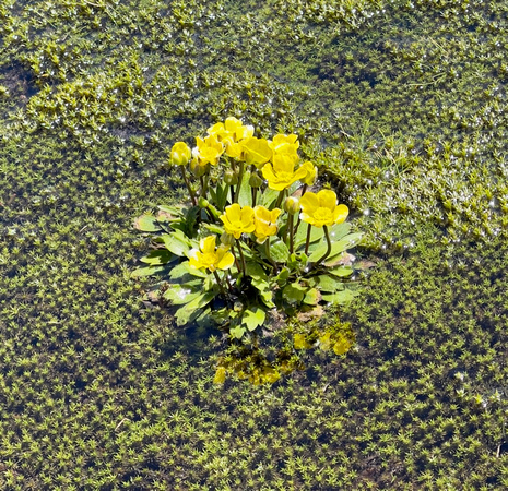
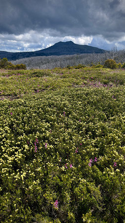
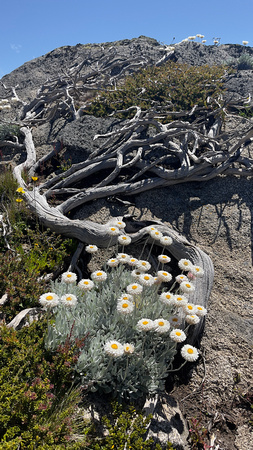
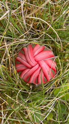
There were many wildflowers out at this time of the year but some of it was spoilt with many weeds.
Day 1
We drove from Canberra to the Round Mountain car park. We arrived around 1030. From the Round Mountain car park we walked along the Round Mountain Fire Trail to Derschkos Hut. After a short stop at the hut we left grabbed our day packs and decided to head up to Jagungal for sunset. The plan was to stay for sunset and walk back in the dark if we were confident in finding the track on the way back. After leaving the Grey Mare Trail and navigating our way up the footpad to Jagungal the track was not that hard to follow but was surrounded by chest high undergrowth. We made a decision to leave the summit prior to sunset so we could find our way back down.
We left the summit just after 1900 and returned to the hut around 2130
Day 2
We left Derschkos Hut around 0900 and headed down the Grey Mare Trail to Grey Mare Hut. We arrived at Grey Mare Hut at 1300 where we had lunch and a short break. We left Grey Mare Hut at around 1430 and walked down the Valentine Fire Trail to Back Flat Creek. The map shows a track from Valentine Fire Trail along Back Flat Creek to Valentine Falls but we did not find any track, we walked through sometimes shoulder high undergrowth until we got to Valentine Falls. The falls were spectacular and flowing very nicely. Talking to others afterwards it seems that there has been no track for some time.
Given that there was no track to the falls, we did not even attempt trying to find the track up the right hand side of the falls. We made a decision to head straight from the base of the falls directly up the mountain to Valentine's Hut. This started off with some nice boulder hoping but soon developed into some serious bush bashing, scaling large fallen gums and climbing over large boulders. On reaching the top of the mountain there was a short drop to Valentine Creek made easier by hanging on to the undergrowth on the way down. Once reaching the creek we spotted a cairn just on the other side and after crossing the creek we found a footpad that lead to Valentines Hut. We reached the hut close to 2100 and totally exhausted.
Day 3
The third day we walked from Valentine's Hut to O'Keefe's Hut along Valentine Fire Trail and Grey Mare Trail. The temperature was only mid twenties but it felt hot and we wet our hats and shirts in every stream we crossed. O'Keefe's Hut is interesting in that it has old newspapers covering the interior walls. The snow grass just outside the hut was very comfortable to set up the tents on.
Day 4
This was our last day and we were heading back to the Round Mountain car park. We left around 0830 and soon after it started to rain and did not stop until we go to Tumut River valley. A problem is trying to use an iPhone for navigation and taking photos is that the touch screens do not work well in the rain. We nearly missed the turn off from the Grey Mare trail we only made a further 10m before we realised though, the sign at the turn off is fairly obscured by bush when heading north.
The Tumut River valley was very picturesque surrounded in mist. We walked down into the valley and met another group just starting their trip. They were taking off their boots to cross the river. They were surprised that we did not bother taking off our boots but I told them that they could not get any wetter than they already were.
After crossing the river we walked up to the remains of Round Mountain Hut where we had lunch and then walked to the Round Mountain car park. Near the car park we were talking to someone who was doing a road trip through the mountains on his own. We walked back to the car park with him and he very kindly offer me a very welcome ice cold beer.


Summary: 2 day hike from Guthega to the Sentinel via the new Guthega to Charlotte Pass Track and return via Mount Twynam and Mount Tate
Date: 22-23 January 2022
Region: Kosciuszko National Park
Introduction
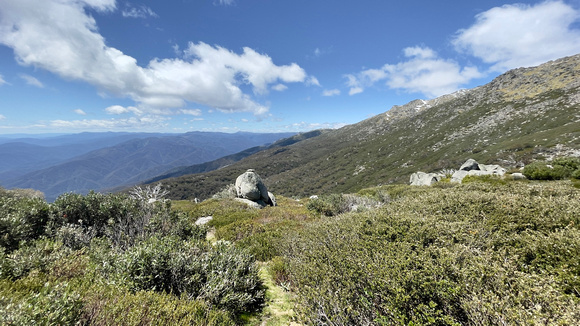
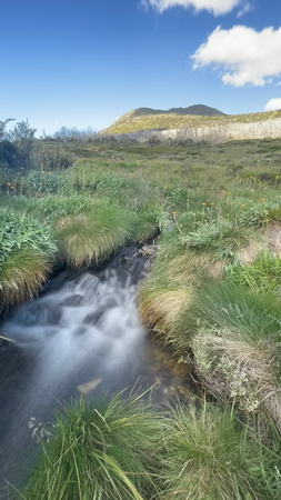
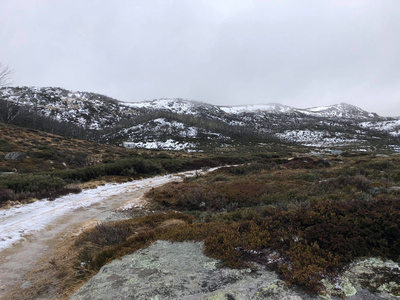
There were many wildflowers around this year due to the amount of rain. For this hike we parked at Guthega and walked the new track to Charlotte Pass. From there we joined the Main Range track and hiked up past Blue Lake and onto the Sentinel. There were many wildflowers around this area.
The following day we had planned to walk back to Guthega via Mount Twynam, Mount Anderson and Mount Tate. Then cut across at Consett Stephen Pass and down to Guthega Trig.
Day 1
We parked the car at Guthega and hiked along the new Guthega to Charlotte Pass walking track.
"This walk is the first section of the new, multi-day Snowies Alpine Walk in stunning Kosciuszko National Park.
This invigorating 9km walking track on Monero Ngarigo Country winds from Guthega to Charlotte Pass. It offers breathtaking views, fresh alpine air, and a truly immersive adventure in the Snowy Mountains." (NationalParks.nsw.gov.au)
The walk was fairly easy on the new track and the views along Spencer's Creek are spectacular. The track winds along Spencer's Creek and through snow gum forests.
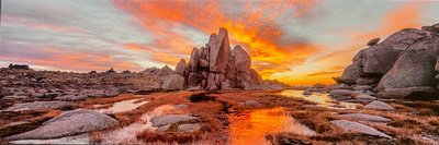
After joining the Main Range track just above Foreman's Crossing we headed up towards Blue Lake and on to the Sentinel. We set up camp overlooking the Sentinel.
Day 2
After packing up and having breakfast we started the ascent up to Mount Twynam. From Mount Twynam we followed the foot pad down past Mount Anton and Mount Anderson through to Mount Tate. There were not many places along here to fill up with water, we did have enough to get us through the hike though.
After passing Mount Tate and up toward Consett Stephen Pass we left the footpad and navigated our way through the vegetation across to the ridge that leads down to Guthega Trig. Near Guthega Trig we picked up the footpad that leads down to Guthega dam and back up the road to the Guthega car park.
]]>


Summary: 3 day hike from Cascades Car Park to Teddy's Hut and return and then to North Ramshead and return
Date: 23-25 April 2022
Region: Kosciuszko National Park
Introduction
Teddys Hut is 10kms from the Cascades Car Park.
Teddy McGufficke together with Dave and Noel Pendergast started building this hut in late December 1948 for grazing and brumby running. In 2003 Teddys Hut avoided damage in the raging bush fire which led to the destruction of other shelter huts in the Kosciusko National Park. (Khuts.org)
The plan for this trip was to walk to Teddys Hut and camp the night. The next day we would return to Cascades for lunch and then climb the Dead Horse Gap track and then on to North Ramshead where we would camp the second night. The third morning we would walk back down the Dead Horse Gap track to Cascades.
Day 1
The walk started at the Cascade car park. We followed the road to Cascade Hut and before the bridge we turned left and followed the Thredbo River. The track is fairly defined for a few kilometers. You could see where the brumbies had been - huge mounds of droppings right along the river. Just over half way to Teddys Hut the track is not very well defined, I think we were just following brumby tracks. We stopped and had lunch along the river, it very picturesque with a few cascades running through the granite boulders. Along the track there were a few flame robins seemingly checking us out.
After lunch we continued to follow the river, the walking got very hard in places with the ground being very boggy. We subsequently got some advice that we should have left the river at that stage and continued higher. We arrived at the hut in the afternoon and had a good look around the hut and where to fill up with water. Again there were large mounds of brumby droppings all around. We found a nice clear spot on the snow grass to set up the tents a little away from the hut.
After setting up the tents the sun started to set and it started to get a little cold, we started a little fire and sat around for a few more hours before venturing in for a good nights sleep on the nice soft snow grass.
Day 2
There was nice light on the hut at sunrise through the large snow gums, it would have made a nice shot except for the large brumby mound between the gums. We spotted a few brumbies down near the edge of the trees just up from the river.
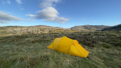
Following breakfast and packing up our gear we walked out via the same track, again crossing the large boggy area sometimes sinking well up past our boots in mud. After we returned to the Cascade Hut road we spotted 2 deer near the river. Back at Cascades car park I pulled out the little gas burner and heated up a very nice lunch. After a lunch and a very short break we grabbed our packs and headed up Dead Horse Gap track. Near Golf Course Bowl we deviated from the track and headed towards North Ramshead. Up towards North Ramshead there were more signs of brumbies. We set up our tents near Aries Tor.
Day 3
The sunrise on Day 3 at Aries Tor was spectacular. After breakfast and packing up we headed back down to find the Dead Horse Gap track and hike back down to the car at Cascades. On the way down we spotted another deer not far from North Ramshead.


Summary: 2 day hike from Geehi Flat to Thredbo via Hannel's Spur
Date: 13-14 February 2021
Region: Kosciuszko National Park
Introduction
The Hannel's Spur walking track climbs 1800m from Geehi Flat to Mount Kosciuszko. It is the greatest vertical ascent in Australia and the same route Paul Strzelecki, James McArthur and two aboriginal guides took as Strzelecki became the first European to climb, and to name, Kosciuszko in 1840. The walk is very tough but offers spectacular views across the western fall of the Snowy Mountains.
The sign at the bottom of the walk says 15.5kms one way to Kosciuszko. We did a car shuffle leaving one car at Thredbo and continued to a car park across the Swampy Plains River from Dr. Forbes Hut and walked back to Thredbo. The walk from Geehi Flat to Thredbo is just over 20kms with the last 6 being fairly easy along the Main Range and Thredbo to Kosciuszko walking tracks.
Day 1
The walk started at the car park across the Swampy Plains River from Dr. Forbes Hut. There were 4 of us on the walk. I was expecting the walk to be difficult but was not really expecting that it would start off with a difficult river crossing. The previous day it had rained and the Swampy Plains River was flowing fairly well. I removed my shoes and zipped off the bottom of my hiking pants and stepped into the river. The water came up to my waist. With a relatively heavy pack there was a number of times I thought that I was going to get washed away, but I made it safely across the other side.
At the hut we dried off and put our shoes back on and headed off on the walk. At the bottom of the walk there is a sign that says 6.5kms to Moira Flat and 15.5kms to Kosciuszko with an 1800m climb. The day was warm but the walk is through heavy forest that provides some shade. It seemed to take forever to get to Moira Flat where we had a lunch stop and this is the first place you can replenish your water. The first person to reach Moira's Flat came across a large snake that wanted to use the walking track as its path. It eventually moved off the track.
After a short break we continued up to the top of Hannel's Spur. As you start to emerge from the trees there are spectacular views in all directions. On reaching the top of Hannel's Spur with plenty of daylight left we discussed setting up camp or moving on to try and reach Wilkinson's Creek. We decided to move on. As we progressed it looked more and more like we would not make Wilkinson's Creek in daylight, we then decided to try and find a camp site at around 7pm.
After having walked 12kms and climbed 1510m, we found a really nice grassy area with spectacular views and set up camp to watch the sun go down over the Victorian Mountains.
Day 2
After waking to a beautiful sunrise across Wilkinson's Valley, we packed up camp and headed to Wilkinson's Creek where we spent some time exploring and taking a well deserved swim in the brisk water. We then headed to towards Mueller's Pass to meet the Main Range walking track where we followed the track back to Eagle's Nest where we were expecting to celebrate. They closed the doors just as we were walking up the stairs to the restaurant.
We caught the lift down, stopped for a short time at the cafe and then returned to get the car we left in the car park at Geehi Flat.
The walk on day 2 was 11kms and very relaxing with only a 350m climb.


 Summary: Day hike to White's River Hut
Date: 14 June 2020
Region: Kosciuszko National Park
This was a quick day trip from Canberra for a walk in the mountains. We had originally planned to walk the Main Range but the forecast was for heavy winds and snow. We changed our plan and decided that the walk up Disappointment Spur to White's River Hut would provide some shelter from the winds. When we got to the Guthega Power Station the creek crossing looked a bit dangerous with quite a bit of water flowing over the rocks at the crossing. We then decided not to take a chance of falling in the creek and headed up the main road. At the top of the steep section we took a left and walked the track on the high side of Horse Camp Hut.
At the start of the day we had fairly heavy sleet which then turned into light snow around Horse Camp Hut. The walk was very sheltered from the winds until we were a few hundred metres from White's River Hut. After lunch we headed back to the power station along the main road.


]]>
 Summary: 3 day hike to Tarn Bluff with the Canberra Bushwalking Club
Date: 4-6 November 2017
Region: Jagungal Wilderness - Kosciuszko National Park
Introduction
From the time I had read that Bluff Tarn was one of the prettiest spots in the mountains, especially when there is still snow about (Robert Green - Exploring the Jagungal Wilderness), I knew I had to make a visit. In early November of 2017 the Canberra Bushwalking Club planned a trip to this area and I put my name down straight away. Heading up to the weekend the weather forecast did not look great but the snow was thinning above 1900m so the walking should not be that hard, so we decided to go ahead with the trip.
Day 1
The weekend started as we left Canberra at 7.30 on the Saturday morning and headed through Cooma to Snowy Plain. Crossing the Gungarlin River was fairly easy, we did not need to use the "bridge". We parked the car in the paddock along side the road put on our packs and started the hike. The first part of the trip was an easy hike down to Teddy's Creek for morning tea. From there we headed up through Little Brassy Gap and on towards Kidman's Hut. The walk down to Kidman's Hut required some navigating over some large boulders and a creek crossing. After a short stop at Kidman's Hut we pressed on for a short time until we found a nice spot to camp. We set up camp just below Burrungubugge Gorge.
Day 2
Leaving the tents set up we set off up the Burrungubugge Gorge and on towards Mailbox Hill. On top of Mailbox Hill we could see Jagungal and Tarn Bluff in the distance. We made a decision here to continue on to Tarn Bluff. At Tarn Bluff there was still some snow around the edges around the tarn. There was also some very nice old snow gums on top of the Bluff, some of the few to survive the fires. After lunch we returned via the same route back to the campsite.
Day 3
During the night we had a bit of snow around the campsite but there had been quite a bit of snow just a little higher. Only a few hundred metres from the campsite, up around Burrungubugge Gorge, was completely white. The snow, rain and sleet continued all the way back to the car. The Gungarlin River had risen and would have been dangerous to cross, so I had to cross the metal "bridge". It was not as bad as I thought it would be.
]]>